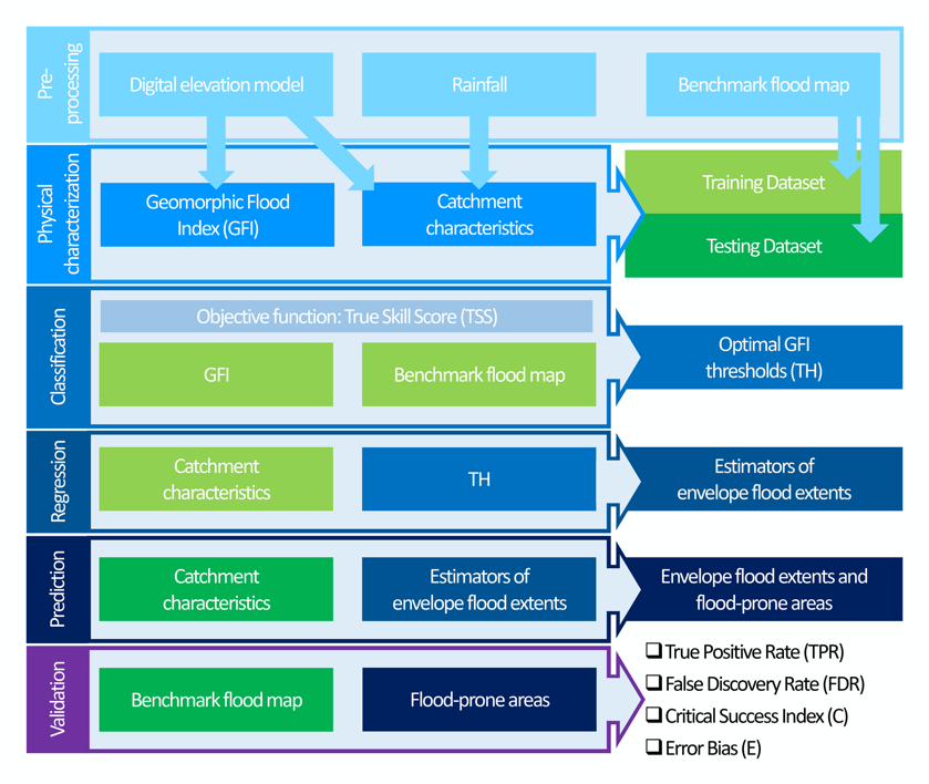
IAHS Academy
This week we launched the first IAHS Academy course: “Advanced Hydrological Monitoring”, hosted by Eastern Institute of Technology (EIT), Ningbo, China. A strong, highly engaged cohort of students is joining…
Università degli Studi di Napoli Federico II - DICEA
This week we launched the first IAHS Academy course: “Advanced Hydrological Monitoring”, hosted by Eastern Institute of Technology (EIT), Ningbo, China. A strong, highly engaged cohort of students is joining…
Flood events are among the most destructive natural hazards, requiring comprehensive risk management strategies to mitigate their impact on society and the environment. This study uses the potential of the…
This non-exhaustive collection of publications offers a concise overview of the scientific journey of Prof. Mauro Fiorentino — mentor, friend, and scholar who profoundly shaped the evolution of hydrology in…
In recent years, significant advancements in geomorphic methods have provided a valuable and cost-effective alternative for large-scale flood mapping. The Geomorphic Flood Index (GFI) is one such method that has…
Flood events rank among the most destructive natural hazards, necessitating comprehensive risk management strategies to mitigate their impact on society and the environment. Various approaches have been developed to map…
Flood extent delineation techniques have benefited from the increasing availability of remote sensing imagery, classification techniques and the introduction of geomorphic descriptors derived from Digital Elevation Models (DEM). On the…
The IAHS – International Association of Hydrological Sciences is proud to announce dates (July 20-27, 2024) and Venue (Cairo, Egypt) of the first edition of the IAHS Academy, the newly…
Satellite remote sensing is a highly valuable data source useful in the monitoring of surface water dynamics and an essential tool in flood risk management although several factors can interfere…
This study suggests a rapid methodology to delineate areas prone to flood using machine learning techniques. Based on available historically flooded areas, the model employs and combines globally collectible and…
The geomorphic flood index (GFI) method provides a good representation of flood-prone areas. However, the method does not account for floodwater transfers in undefined interbasins (UIBs), which represent intercluded small…
Climate change and landuse transformations have induced an increased flood risk worldwide. These phenomena are impacting dramatically on ordinary life and economy. Research and technology offer new strategy to quantify…
A topographic index (flood descriptor) that combines the scaling of bankfull depth with morphology was shown to describe the tendency of an area to be flooded. However, this approach depends…
Large-scale flood risk assessment is essential in supporting national and global policies, emergency operations and land-use management. The present study proposes a cost-efficient method for the large-scale mapping of direct…
In recent years, the acquisition of data from multiple sources, together with improvements in computational capabilities, has allowed to improve our understanding on natural hazard through new approaches based on…
GFA – tool is an open-source QGIS plug-in to realize a fast and cost-effective delineation of the floodplains in the contexts where the available data is scarce to carry out…