


Impact of climate change on evaporation in Mosul Dam reservoir-Iraq
Water resources in Iraq are considered one of the elements most affected by climate change, especially water bodies, and the loss of water from reservoirs by evaporation is one of the most losses that occur in semi-arid countries. Hence, a study of a subject in this regard is very necessary, ...
Remote Sensing for Monitoring Macroplastics in Rivers: A Review
Given the exponential rise in global plastic production and its significant ecological and socio-economic impacts, monitoring macroplastics in rivers has become a central focus of water management efforts. However, standardized monitoring methodologies are lagging behind the rate of plastic waste currently entering aquatic systems on a global scale. This translates ...
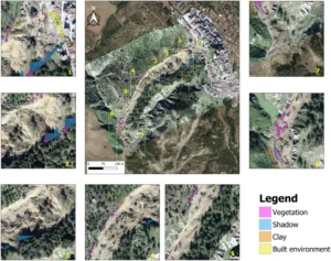
Rapid landslide detection from free optical satellite imagery using a robust change detection technique
In the last decades, the availability of multi-source, multi-scale, and multi-resolution remote sensing data and the consequent progress of processing techniques brought a significant positive impact for landslide detection. As a result, nowadays also public institutions dealing with geo-hazard management worldwide regularly use satellite data and products in landslide investigations ...
HESS Opinions: Towards a common vision for the future of hydrological observatories
The Unsolved Problems in Hydrology (UPH) initiative has emphasized the need to establish networks of multi-decadal hydrological observatories to gain a deep understanding of the complex hydrologic processes occurring within diverse environmental conditions. The already existing monitoring infrastructures have provided an enormous amount of hydrometeorological data, facilitating detailed insights into ...
Understanding spatio-temporal complexity of vegetation using drones, what could we improve?
Unraveling the intricate spatial and temporal complexities of vegetation represents a crucial key to understanding ecosystem functioning. Drones, as cutting-edge technology, hold immense potential in bridging the gap between on-ground measurements and satellite remote sensing data. Nonetheless, a multitude of challenges still looms, with one of the foremost being the ...
The Space–Time Representation of Extraordinary Rainfall Events
Extraordinary events are rarely observable in a single rainfall gauge, and this make extremely challenging the correct prediction of their arrivals. However, it may be possible to develop a more robust approach by employing a space–time modelling scheme that is able to capture the spatial dynamics of such phenomena. Therefore, ...
Generation of root zone soil moisture from the integration of an all-weather satellite surface soil moisture estimates and an analytical model: A preliminary result in China
In addition to surface soil moisture (SSM) data, root zone soil moisture (RZSM) is particularly significant for irrigation decision-making and agricultural drought warnings since water uptake generally occurs through the root systems of plants. In this study, a daily/0.05° RZSM dataset covering the major land areas of China was generated ...
Image processing for continuous river turbidity monitoring – full scale tests and potential applications
The development of continuous river turbidity monitoring systems is essential, since it is a critical water quality metric linked to the presence of organic and inorganic suspended matter. Current monitoring practices are mainly limited by low spatial and temporal resolution, and costs. This results in the huge challenge to provide ...