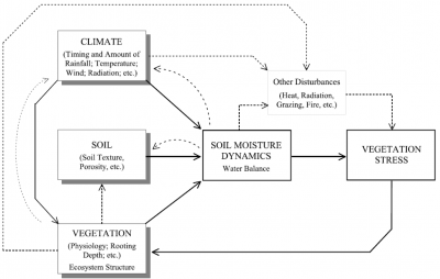
Soil Moisture (SM) is a vital element in the hydrological cycle and vegetation growth. Quantification of SM and its spatio-temporal variability are valuable for understanding water availability in agriculture, land-atmosphere interactions, ecosystem states, river basin hydrology and water resources management.
Space-time dynamics
In the work by Isham et al. (2005), Rodríguez-Iturbe et al. (2006) and Manfreda and Rodríguez-Iturbe (2006), the spatial and temporal dynamics of soil moisture are studied assuming homogeneous soil and negligible topographic effects. The analysis centers on a stochastic model that accounts for the spatial and temporal variability of rainfall and incorporates effects of spatial heterogeneity of vegetation. The approach, although a very simplified representation of an enormously complex problem, yields an analytical framework for the description of the spacetime dynamics of relative soil moisture that clearly indicates the role of vegetation and rainfall parameters under general conditions. This type of framework may be very useful in the attempt to establish general criteria for the description of the soil moisture over a range of spatial and temporal scale.
The use of remote sensing data
Remote sensing offers an extraordinary opportunity to quantify land surface soil moisture (SSM) and root zone soil moisture (RZSM). The currently existing satellite observed SSM products include passive and active microwave observations. The Soil Moisture and Ocean Salinity (SMOS) and the Soil Moisture Active Passive (SMAP) are specialized to SSM monitoring, which are also producing the RZSM product based on SSM product. There are also several SSM products that are retrieved from satellites originally designed for other purposes, for example, the Advanced Microwave Scanning Radiometer (AMSR) SSM products retrieved while using the Land Parameter Retrieval Model, and the Advanced Scatterometer (ASCAT) SSM products retrieved with change detection method.
It is to note that the SSM provides information on the degree of surface saturation that can be transformed into an estimate within the root‐zone soil layer while using mathematical and statistical filters (Manfreda et al., 2014). These method has been implemented and tested on several sites and areas: Africa (Manfreda et al., 2014); United States (Baldwin et al, 2017); Iran (Gheybi et al., 2019); Tibetan Plateau (Zhuang et al., 2020);
Use of UAS for SM monitoring
Thermal and optical remote sensing provides a possibility to observe land surface information at a wide range of resolution because the thermal and optical signals from the land surface are strong and the sensors can be mounted not only on the satellites but also on airplane or UAS. For example, the products from the Moderate Resolution Imaging Spectroradiometer (MODIS, 1km) and LANDSAT program (30m-100m optical and thermal infrared data). However, thermal and optical remote sensing is limited significantly by the weather condition.
Nevertheless, airborne remote sensing, especially the UAS provides a possibility to obtain sub-meter land surface information in an efficient, flexible and economical way (Manfreda et al., 2018; Tmušić et al., 2020). In various application cases, high resolution continuous SM maps are necessary. For agricultural applications, the study usually focuses on a field scale and requires detailed SM information up to plot/plant scales. Also, drought monitoring and fine-scale water budget assessment are requiring high resolution SM data.
Numerous studies proved the ability of SM retrieval from UAS based optical and thermal remote sensing. For optical remote sensing-based methods, the Kubelka-Munk model provides a possibility to derive surface SM directly from shortwave reflectance data. For thermal infrared-based methods, one of the well-established methods is the thermal inertia method, which was a classical method of satellite-based remote sensing and currently also applied with UAS data. Paruta et al., (2020) presented a good example of using UAS based thermal inertia method for surface SM estimation over bare soil and sparsely vegetated area and showed a satisfactory result against in-situ measured SM data. Another recommended method is the temperature-vegetation triangle method, which makes the evapotranspiration and SM estimation possible. Wang et al., (2018) gave a good example of root zone SM estimation using a modified temperature-vegetation triangle model with the help of land surface roughness data from UAS optical data. Petropoulos et al., (2021) also gave examples of surface SM and evapotranspiration estimation using simplified triangle models and presented a good result validated with in-situ measurements. Also, UAS based land surface information can be used in the surface SM downscaling procedure with machine learning (Su et al., 2020).
As it is still a primary stage of research on UAS based SM monitoring, the standardization of operational procedures can be beneficial to understanding and guaranteeing the quality of retrieved soil moisture (Manfreda et al., 2018; Tmušić et al., 2020). For example, when different SM retrieval models are going to be used, the sensor type and the acquisition time should be well-planned based on the theory and the follow-up processing methodology.
References
- Zhuang, R., S. Manfreda, Y. Zeng, Z. Su, E. Ben Dor and G. P. Petropoulos, Soil moisture monitoring using unmanned aerial system, in Unmanned Aerial Systems for Monitoring Soil, Vegetation, and Riverine Environments edited by S. Manfreda and E. Ben Dor, Elsevier, 2023. [Link]
- Paridad, P., S.F. Dal Sasso, A. Pizarro, L. Mita, M. Fiorentino, M.R. Margiotta, F. Faridani, A. Farid, and S. Manfreda, Estimation of soil moisture from UAS platforms using RGB and thermal imaging sensors in arid and semi-arid regions, ACTA Horticulture (in press), 2021.
- Petropoulos, G.P., A. Maltese, T. N. Carlson, G. Provenzano, A. Pavlides, G. Ciraolo, D. Hristopulos, F. Capodici, C. Chalkias, G. Dardanelli, S. Manfreda, Exploring the use of UAVs with the simplified “triangle” technique for Soil Water Content and Evaporative Fraction retrievals in a Mediterranean setting, International Journal of Remote Sensing, 42(5), 1623–1642, (doi: 10.1080/01431161.2020.1841319) 2021. [pdf]
- Paruta, A., P. Nasta, G. Ciraolo, F. Capodici, S. Manfreda, N. Romano, E. Bendor, Y. Zeng, A. Maltese, S. F. Dal Sasso and R. Zhuang, A geostatistical approach to map near-surface soil moisture through hyper-spatial resolution thermal inertia, IEEE Transactions on Geoscience and Remote Sensing, 59(6), 5352 – 5369, (doi: 10.1109/TGRS.2020.3019200) 2021. [pdf]
- Su, Z., Y. Zeng, N. Romano, S. Manfreda, F. Francés, E.B. Dor, B. Szabó, G. Vico, P. Nasta, R. Zhuang, N. Francos, J. Mészáros, S.F. Dal Sasso, M. Bassiouni, L. Zhang, D.T. Rwasoka, B. Retsios, L. Yu, M.L. Blatchford, C. Mannaerts, An Integrative Information Aqueduct to Close the Gaps between Satellite Observation of Water Cycle and Local Sustainable Management of Water Resources, Water, 12, 1495, (doi: 10.3390/w12051495) 2020. [pdf]
- Tmušić, G., S. Manfreda, H. Aasen, M. James, G. Gonçalves E. Ben-Dor, A. Brook, M Polinova, J.J. Arranz, J. Mészáros, R. Zhuang, K. Johansen, Y. Malbeteau, I.P. de Lima, C. Davids, S. Herban, M. McCabe, Practical guidance for UAS-based environmental mapping, Remote Sensing, 12, 1001, (doi: 10.3390/rs12061001) 2020. [pdf]
- Zhuang, R.; Y. Zeng; S. Manfreda; Z. Su, Quantifying Long-term Land Surface and Root Zone Soil Moisture over Tibetan Plateau, Remote Sensing,12, 509, (doi: 10.3390/rs12030509) 2020. [pdf]
- Baldwin, D., S. Manfreda, H. Lin, and E.A.H. Smithwick, Estimating root zone soil moisture across the Eastern United States with passive microwave satellite data and a simple hydrologic model, Remote Sensing, 11, 2013, (doi: 10.3390/rs11172013), 2019. [pdf]
- Lazzari, M., M. Piccarreta, and S. Manfreda, The role of antecedent soil moisture conditions on rainfall-triggered shallow landslides, Natural Hazards Earth System Science Discussion, (doi: 10.5194/nhess-2018-371) 2019. [pdf]
- Manfreda, S., M. F. McCabe, P. E. Miller, R. Lucas, V. Pajuelo Madrigal, G. Mallinis, E. Ben-Dor, D. Helman, L. Estes, G. Ciraolo, J. Müllerová, F. Tauro, M. I. de Lima, J. L. M. P. de Lima, A. Maltese, F. Frances, K. Caylor, M. Kohv, M. Perks, G. Ruiz-Pérez, Z. Su, G. Vico, and B. Toth, On the Use of Unmanned Aerial Systems for Environmental Monitoring, Remote Sensing, 10(4), 641; (doi:10.3390/rs10040641) 2018. [pdf]
- Faridani, F., A. Farid, H. Ansari, S. Manfreda, A modified version of the SMAR model for estimating root-zone soil moisture from time series of surface soil moisture, Water SA, Vol. 43 No. 3 July 2017 (doi: 10.4314/wsa.v43i3.14), 2017. [pdf]
- Albano, R., S. Manfreda, G. Celano, MYSIRR: Minimalist agro-hYdrological model for Sustainable IRRigation management – soil moisture and crop dynamics, SoftwareX, 6, 107–117, (doi: 10.1016/j.softx.2017.04.00), 2017. [pdf]
- Baldwin, D., Manfreda, S., Keller, K., and Smithwick, E.A.H., Predicting root zone soil moisture with soil properties and satellite near-surface moisture data at locations across the United States, Journal of Hydrology, 546, 393-404, (doi: 10.1016/j.jhydrol.2017.01.020), 2017. [pdf]
- Manfreda, S., K. K. Caylor, S. Good, An Ecohydrological framework to explain shifts in vegetation organization across climatological gradients, Ecohydrology, 10(3), 1-14, (doi: 10.1002/eco.1809), 2017. [pdf]
- Faridani, F., A. Farid, H. Ansari, and S. Manfreda, Estimation of the root-zone soil moisture using passive microwave remote sensing and SMAR model, Journal of Irrigation and Drainage Engineering, 04016070, 1-9, (doi: 10.1061/(ASCE)IR.1943-4774.0001115), 2016. [pdf]
- Calamita, G., A. Perrone, L. Brocca, B. Onorati, S. Manfreda, Field test of a multi-frequency electromagnetic induction sensor for soil moisture monitoring in southern Italy test sites, Journal of Hydrology, 529(1), 316–329, (doi: 10.1016/j.jhydrol.2015.07.023), 2015. [pdf]
- Manfreda, S., L. Brocca, T. Moramarco, F. Melone, and J. Sheffield, A physically based approach for the estimation of root-zone soil moisture from surface measurements, Hydrology and Earth System Sciences, 18, 1199-1212, (doi:10.5194/hess-18-1199-2014), 2014. [pdf]
- Manfreda, S., K.K. Caylor, On The Vulnerability of Water Limited Ecosystems to Climate Change, Water, 5(2), 819-833; (doi:10.3390/w5020819), 2013. [pdf]
- Manfreda, S., T.M. Scanlon, K.K. Caylor, On the importance of accurate depiction of infiltration processes on modelled soil moisture and vegetation water stress, Ecohydrology, 3, 155-165, (doi: 10.1002/eco.79), 2010. [pdf]
- Manfreda, S., Ecohydrology: a New Interdisciplinary Approach to Investigate on Climate-Soil-Vegetation Interactions, Annals of Arid Zones, 48 (3 & 4), 219-228, (ISSN: 0570-1791), 2009. [pdf]
- Gigante V., P. Milella, V. Iacobellis, S. Manfreda, and I. Portoghese, Influences of Leaf Area Index estimations on the soil water balance predictions in Mediterranean regions, Natural Hazard and Earth System Sciences, 9, 979-991, (doi:10.5194/nhess-9-979-2009), 2009. [pdf]
- Manfreda, S., Runoff Generation Dynamics within a Humid River Basin, Natural Hazard and Earth System Sciences, 8, 1349-1357, (doi:10.5194/nhess-8-1349-2008), 2008. [pdf]
- Manfreda, S., M. Fiorentino, A Stochastic Approach for the Description of the Water Balance Dynamics in a River Basin, Hydrology and Earth System Sciences, 12, 1189-1200, (doi:10.5194/hess-12-1189-2008), 2008. [pdf]
- Sofo, A., S. Manfreda, B. Dichio, M. Fiorentino, C. Xiloyannis, The Olive Tree: a Paradigm for Drought Tolerance in Mediterranean Climates, Hydrology and Earth System Sciences, 12, 293-301, (doi:10.5194/hess-12-293-2008), 2008. [pdf]
- Manfreda, S., D.R. Cox, V. Isham, A. Porporato, I. Rodríguez-Iturbe, Reply to the Comment by S. Nadarajah on “Space-time modeling of soil moisture: Stochastic rainfall forcing with heterogeneous vegetation”, Water Resources Research, 43, W10602, (doi:10.1029/2007WR006378), 2007. [pdf]
- Manfreda, S., M. McCabe, E.F. Wood, M. Fiorentino and I. Rodríguez-Iturbe, Spatial Patterns of Soil Moisture from Distributed Modeling, Advances in Water Resources, 30(10), 2145-2150, (doi: 10.1016/j.advwatres.2006.07.009), 2007. [pdf]
- Manfreda, S. and I. Rodrìguez-Iturbe, On the Spatial and Temporal Sampling of Soil Moisture Fields, Water Resources Research, 42, W05409, (doi:10.1029/2005WR004548), 2006. [pdf]
- Rodríguez-Iturbe, I., V. Isham, D.R. Cox, S. Manfreda, A. Porporato, Space-time modeling of soil moisture: stochastic rainfall forcing with heterogeneous vegetation, Water Resources Research, 42, W06D05, (doi:10.1029/2005WR004497), 2006. [pdf]
- Isham, V., D.R. Cox, I. Rodríguez-Iturbe, A. Porporato, S. Manfreda, Representation of Space-Time Variability of Soil Moisture, Proceedings of the Royal Society A: Mathematical, Physical and Engineering Sciences, 461(2064), 4035-4055, (doi:10.1098/rspa.2005.1568), 2005. [pdf]
- Caylor, K.K., S. Manfreda, I. Rodríguez-Iturbe, On the Coupled Geomorphological and Ecohydrological Organization of River Basins, Advances in Water Resources, 28(1), 69-86, (doi: 10.1016/j.advwatres.2004.08.013), 2005. [pdf]
- Scanlon, T.M., K.K. Caylor, S. Manfreda, S.A. Levin, I. Rodríguez-Iturbe, Dynamic Response of Grass Cover to Rainfall Variability: Implications the Function and Persistence of Savanna Ecosystems, Advances in Water Resources, 28(3), 291-302, (doi: 10.1016/j.advwatres.2004.10.014), 2005. [pdf]
- Manfreda, S., M. Fiorentino, V. Iacobellis, DREAM: a Distributed model for Runoff, Evapotranspiration, and Antecedent Soil Moisture Simulation, Advances in Geosciences, 2, 31-39, (SRef-ID: 1680-7359/adgeo/2005-2-31), 2005. [pdf]
Attachments
-
 Spatial Patterns of Soil Moisture from Distributed Modeling
-
A physically based approach for the estimation of root-zone soil moisture from surface measurements
-
Estimating root zone soil moisture across the Eastern United States with passive microwave satellite data and a simple hydrologic model
-
Quantifying Long-term Land Surface and Root Zone Soil Moisture over Tibetan Plateau
-
Exploring the use of UAVs with the simplified “triangle” technique for Soil Water Content and Evaporative Fraction retrievals in a Mediterranean setting