The measurement of discharge in medium and large rivers is primarily done through indirect methods that rely on the use of Flow Rating Curves (FRCs), which establish the relationship between water level and streamflow (Chow, 1959; Fenton and Keller, 2001; Kumar, 2011). These FRCs are calibrated using gaugings, which involve synchronized observations of water level and discharge during specific field campaigns (WMO, 2010).
Traditionally, discharge measurements have been obtained using current meters. However, the accuracy of these measurements can be limited by turbulence and high flow velocities (Tazioli, 2011; Moramarco et al., 2004). In recent years, Surface Velocimetry Radar technology, FlowTracker acoustic Doppler velocimeters, and optical cameras coupled with Image Velocimetry techniques have been introduced as alternatives to traditional current meters. These new technologies aim to improve the accuracy of streamflow measurements (Rehmel, 2007; Tauro et al., 2018; Yorke and Oberg, 2002; Manfreda et al., 2018; Manfreda & Eyal, 2023).
Despite technological advancements and the adoption of new monitoring methods, errors and uncertainties still exist in historical hydrological records. Factors such as cost, time, accessibility, and safety impose constraints on the sample size and the range of variability of streamflow measurements. Given these limitations, FRCs derived through curve-fitting methods may exhibit good performance indices but may not necessarily yield accurate predictions due to the limited number of calibration points. Consequently, the common practice of extrapolating high flow values can introduce significant uncertainty in flood statistics and predictions (Yen, 1994; Petersen-Øverleir, 2004; Braca, 2008).
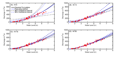
In this context, a new simplified methodology has been introduced by Manfreda (2018), known as the flow-area model. The proposed procedure suggests using flow velocity and wetted cross-section functions to estimate flow rating curves (FRCs). The cross-section flow area can be obtained from topographic surveys, while average flow velocities can be related to the river stage to derive the flow-area rating curve. This method provides an alternative for deriving FRCs by utilizing available information about the river’s cross-section geometry.
The flow-area formulation is particularly beneficial in data-scarce environments and when the observation range is limited. The flow-area model is recommended when fewer than 10 observations are available, while the classical approach is preferable when more measurements can be utilized for FRC estimation. Furthermore, the flow-area model showed improved results when the site had a limited range of observations, especially for low-medium range values.
References
Manfreda, S., E. Ben Dor, Unmanned Aerial Systems for Monitoring Soil, Vegetation, and Riverine Environments, Earth Observation Series, Elsevier, (ISBN: 9780323852838) 1st Edition – January 20, 2023. [Link]
Manfreda, S., A. Pizarro, T. Moramarco, L. Cimorelli, D. Pianese, S. Barbetta, Potential advantages of flow-area rating curves compared to classic stage-discharge-relations. Journal of Hydrology, 585, 124752, (doi: 10.1016/j.jhydrol.2020.124752) 2020. [pdf]
Manfreda, S., On the derivation of flow rating-curves in data-scarce environments. Journal of Hydrogy, 562, 151-154 (doi: 10.1016/j.jhydrol.2018.04.058) 2018. [pdf]
Attachments
-
 On the use of AMSU-based products for the description of soil water content at basin scale
-
A monitoring campaign of soil moisture along a hillslope transect of the experimental basin of Corleto
-
On the derivation of flow rating-curves in data-scarce environments
-
Potential advantages of flow-area rating curves compared to classic stage-discharge-relations