The use of multispectral satellite imagery for water monitoring is a fast and cost-effective method that can benefit from the growing availability of medium–high-resolution and free remote sensing data. Since the 1970s, multispectral satellite imagery has been exploited by adopting different techniques and spectral indices. The high number of available sensors and their differences in spectral and spatial characteristics led to a proliferation of outcomes that depicts a nice picture of the potential and limitations of each. This paper provides a review of satellite remote sensing applications for water extent delineation and flood monitoring, highlighting trends in research studies that adopted freely available optical imagery. The performances of the most common spectral indices for water segmentation are qualitatively analyzed and assessed according to different land cover types to provide guidance for targeted applications in specific contexts. The comparison is carried out by collecting evidence obtained from several applications identifying the overall accuracy (OA) obtained with each specific configuration. In addition, common issues faced when dealing with optical imagery are discussed, together with opportunities offered by new-generation passive satellites.
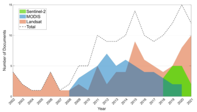
to 2021 using Landsat, MODIS, or Sentinel-2 imagery retrieved from the Scopus academic database.
Keywords: multispectral satellite imagery; water detection; flood mapping; multispectral indices
How to cite: Albertini, C.; Gioia, A.; Iacobellis, V.; Manfreda, S., Detection of Surface Water and Floods with Multispectral Satellites, Remote Sens. 2022, 14, 6005. [pdf]