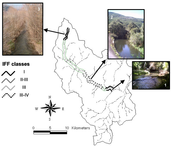
In recent years the need to restore impacted habitats has become a fundamental aspect of environmental management in order to match sustainable development requirements. This is particularly important for fluvial habitats because of their role in the landscapes as environmental corridors. For these reasons the correct management of the restoration ecology interventions is mandatory and the ecosystem characteristics, as well as the influence of its landscape, have to be taken into account. In order to correctly realize buffer strip intervention, one of the most used restoration techniques, we propose an approach which uses field measurements for fluvial functionality and satellite data integrated with hydrological models to obtain information on the landscape influence on the river system. The investigation involved the high valley of the Agri River located in the Basilicata region, Southern Italy. The first step to the analysis involves the investigation of the fluvial ecosystem quality by using the Italian IFF Index (Fluvial Functionality Index), which differentiates various river segments in different levels of functionality. Meanwhile, by using a multispectral satellite image (LANDSAT TM 5) a land use map of the area of interest was performed. This land use map represented an important input for the hydrological simulation, which identified fluvial segments receiving the highest amount of landscape surface runoff, which is the most important cause of pollutant transporting from surrounding areas. All the results have been recorded and integrated in a Geographical Information System to define the final prediction for the localization of the buffer strips. The results obtained underline that the identification of the intervention sites realized by using the IFF field measurements and satellite-based hydrological analyses are complementary since critical segments respectively identified are not completely overlapped. Therefore, an integrated approach is fundamental to better plan the management of restoration ecology interventions.
How to cite: Carone, M.T., S. Manfreda, T. Simoniello, & M. Macchiato, Localization of Buffer Strips by using IFF Field Data and Landsat-TM Satellite Data, Proceedings of River Basin Management III, WITPress, Vol. 83: 193-201, 2005. [Link]