
Author: Salvatore Manfreda

Negli ultimi anni la comunità scientifica ha sviluppato differenti modelli idrologici finalizzati all’approfondimento dei processi a scala di bacino; in particolare differenti tipi di concettualizzazione sono stati utilizzati per descrivere la variabilità spaziale dello stato…
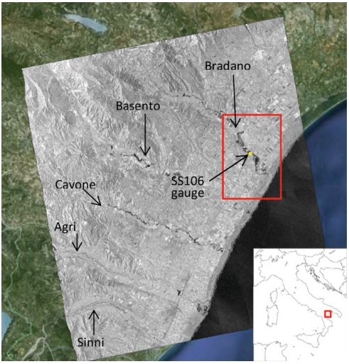
Producing high-precision flood maps requires integrating and correctly classifying information coming from heterogeneous sources. Methods to perform such integration have to rely on different knowledge bases. A useful tool to perform this task consists in…
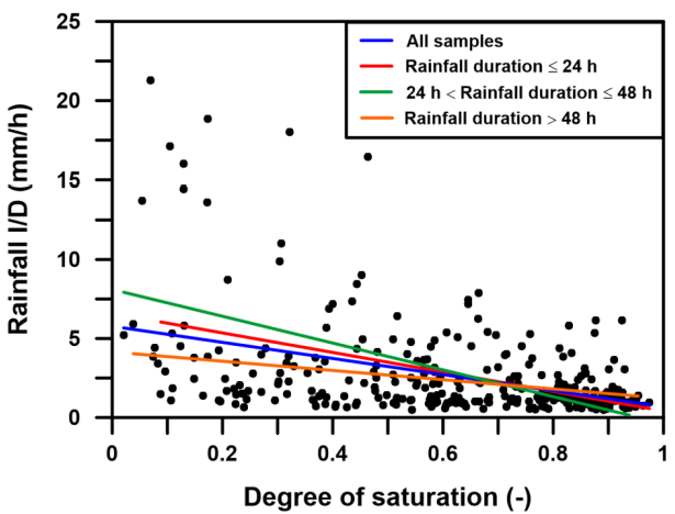
Rainfall-triggered shallow landslides have caused losses of human life and millions of euros in damage to property in all parts of the world. The need to prevent such phenomena combined with the difficulty to describe…
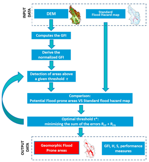
Delineation of flood hazard and flood risk areas is a critical issue, but practical difficulties regularly make complete achievement of the task a challenge. In data-scarce environments (e.g. ungauged basins, large-scale analyses), useful information about…
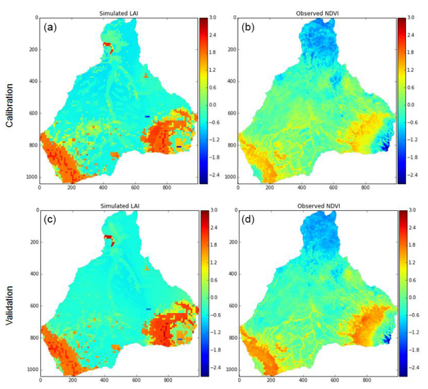
Ecohydrological modeling studies in developing countries, such as sub-Saharan Africa, often face the problem of extensive parametrical requirements and limited available data. Satellite remote sensing data may be able to fill this gap, but require…

The goal of this paper is to introduce the first clear-water scour model based on both the informational entropy concept and the principle of maximum entropy, showing that a variational approach is ideal for describing…

Minimalist agro-hYdrological model for Sustainable IRRigation management – soil moisture and crop dynamics – MY SIRR v.3.0 is a software written in python programming language with a simple Graphical User Interface (GUI) for quantitatively assess and…
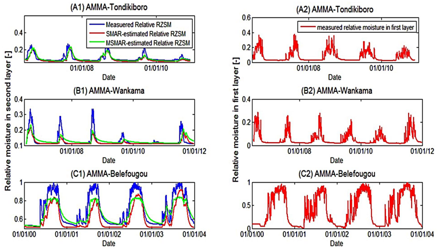
Root-zone soil moisture at the regional scale has always been a missing element of the hydrological cycle. Knowing its value could be a great help in estimating evapotranspiration, erosion, runoff, permeability, irrigation needs, etc. The…
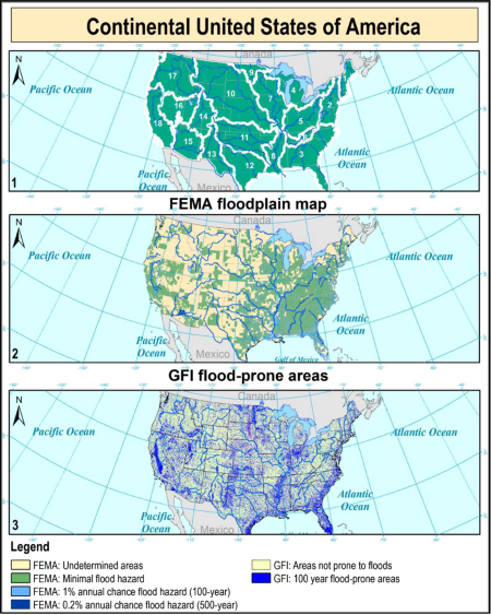
Efficient strategies for preparing communities to protect against,respond to, recover from, and mitigateflood hazard are oftenhampered by the lack of information about the position and extentofflood-prone areas. Hydrologic and hydraulic analyses allow toobtain detailedflood hazard…

Satellite-based near-surface (0–2 cm) soil moisture estimates have global coverage, but do not capture variations of soil moisture in the root zone (up to 100 cm depth) and may be biased with respect to ground-based soil moisture measurements. Here, we present…

The pier scour caused by flood waves is analyzed, introducing the dimensionless effective work by the flow on the sediment bed around the pier, W*. The three-parameter exponential function is adopted to relate the normalized…
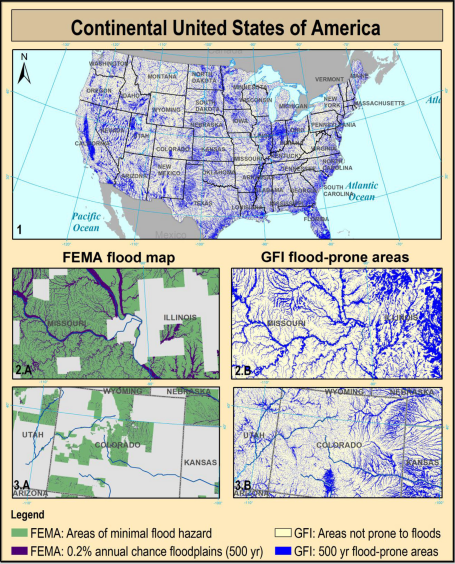
Knowing the location and the extent of the areas exposed to flood hazards is essential to any strategy for minimizing the risk. Unfortunately, in ungauged basins the use of traditional floodplain mapping techniques is prevented…
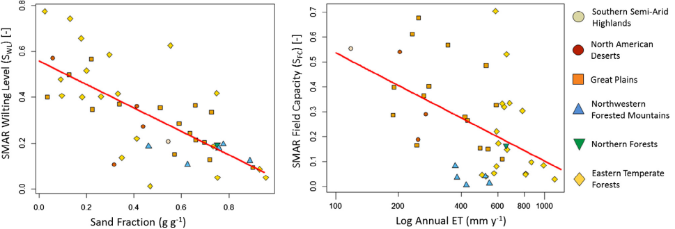
Satellite-based near-surface (0–2 cm) soil moisture estimates have global coverage, but do not capture variations of soil moisture in the root zone (up to 100 cm depth) and may be biased with respect to ground-based…
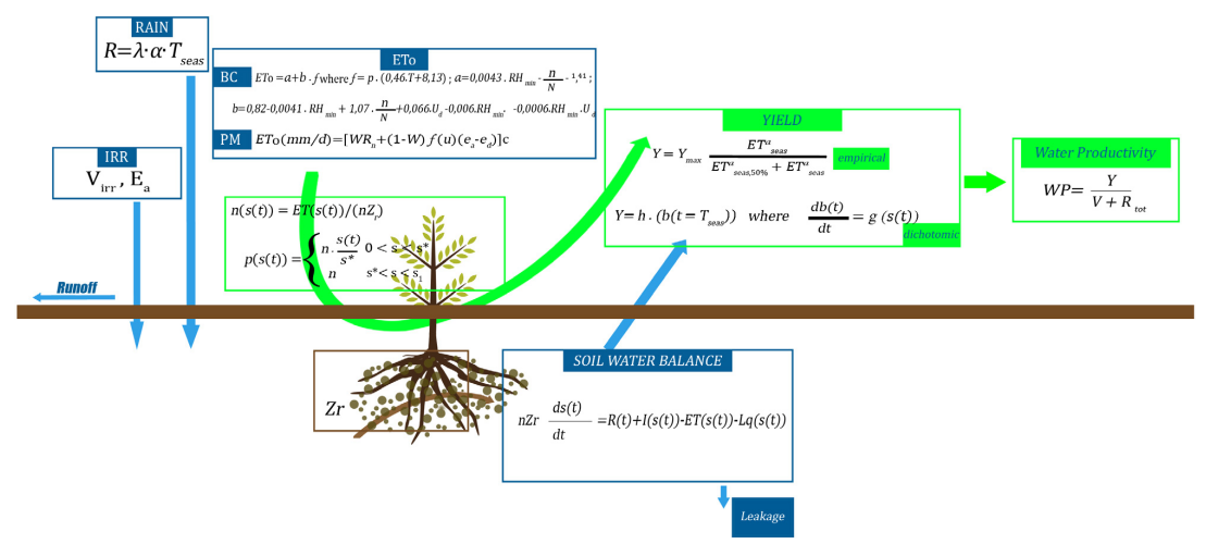
The paper introduces a minimalist water-driven crop model for sustainable irrigation management using an eco-hydrological approach. Such model, called MY SIRR, uses a relatively small number of parameters and attempts to balance simplicity, accuracy, and…
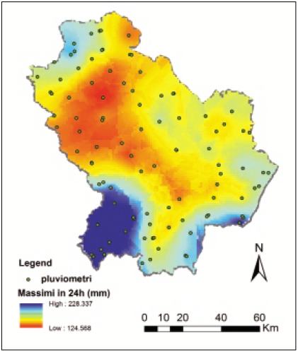
Basilicata is known for the highest frequency of extreme hydrological and geological events. Several landslides and floods have extensively affected the region because of its geological characteristics and dynamics of precipitation producing extensive damage to…