
Category: Publications
Information acquired from Unmanned Aerial Vehicles (UAVs) is frequently used nowadays in a variety of disciplines and research fields. The present study explores for the first time the combined use of UAVs with a newly…

https://meet.google.com/qms-jtbj-zjo 10:00 – 10:20 – I sistemi di allertamento nazionali e regionali: questioni aperte – Fausto Guzzetti (Dirigente Dipartimento Protezione Civile) 10:20 – 10:40 – Impatti e pressioni legati alla gestione delle risorse idriche sui…
River monitoring is of particular interest as a society that faces increasingly complex water management issues. Emerging technologies have contributed to opening new avenues for improving our monitoring capabilities but have also generated new challenges…
This Research Topic seeks to publish articles that demonstrate the utility of image velocimetry techniques for sensing the fluvial environment; that advance the development of image-based techniques; and inform deployment practices for the sensing of…
Climate change and landuse transformations have induced an increased flood risk worldwide. These phenomena are impacting dramatically on ordinary life and economy. Research and technology offer new strategy to quantify and predict such phenomena and…

Il Dipartimento di Ingegneria Civile, Edile e Ambientale (DICEA) dell’Università degli Studi di Napoli Federico II ha recentemente bandito 45 borse di studio per giovani studenti neolaureati e dottori di ricerca che si sono particolarmente…

13 novembre 2020 – 10:00 -13:30 Le scienze idrologiche e le strategie per la mitigazione dei rischi e la tutela dei sistemi naturali – https://meet.google.com/cpy-kmrx-xcu 10:00 – 10:20 – Impatto delle forzanti idrologiche nella sicurezza…
River streamflow monitoring is currently facing a transformation due to the emerging of new innovative technologies. Fixed and mobile measuring systems are capable of quantifying surface flow velocities and discharges, relying on video acquisitions. This…
Thermal inertia has been applied to map soil water content exploiting remote sensing data in the short and long wave regions of the electromagnetic spectrum. Over the last years, optical and thermal cameras were sufficiently…
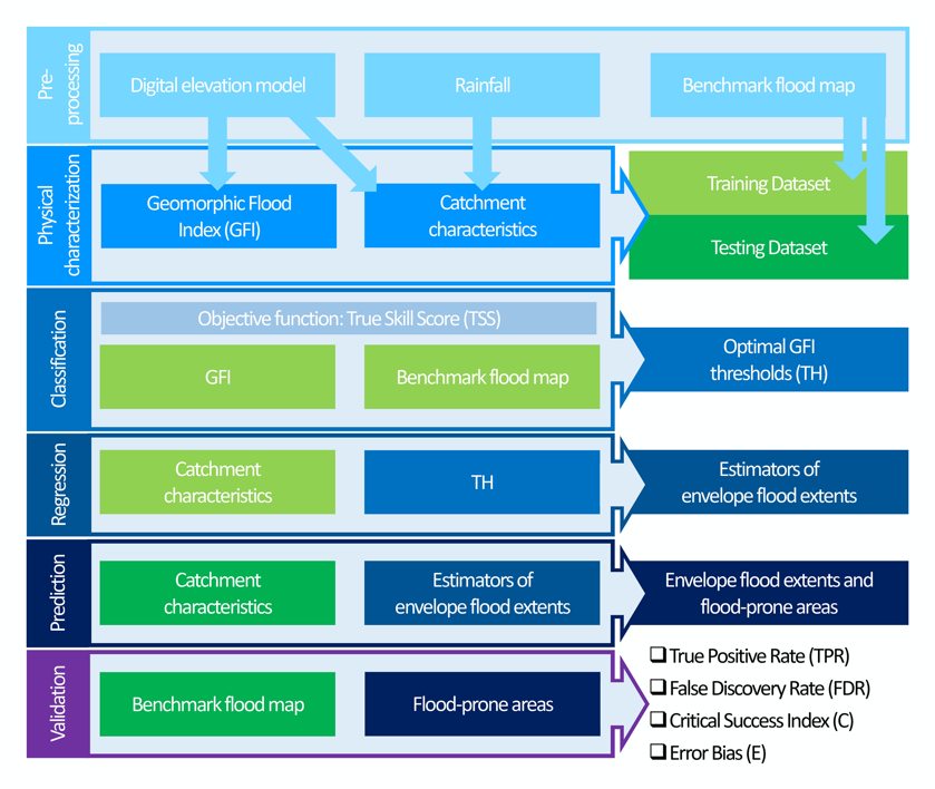
A topographic index (flood descriptor) that combines the scaling of bankfull depth with morphology was shown to describe the tendency of an area to be flooded. However, this approach depends on the quality and availability…
Modeling Antecedent Soil Moisture to Constrain Rainfall Thresholds for Shallow Landslides Occurrence
Rainfall-triggered shallow landslide events have caused losses of human lives and millions of euros in damage to property in all parts of the world. The need to prevent such hazards combined with the difficulty of…
Since the turn of the 21st century, image-based velocimetry techniques have become an increasingly popular approach for determining open-channel flow in a range of hydrological settings across Europe and beyond. Simultaneously, a range of large-scale…
Large-scale flood risk assessment is essential in supporting national and global policies, emergency operations and land-use management. The present study proposes a cost-efficient method for the large-scale mapping of direct economic flood damage in data-scarce…

Dear Colleagues, Recent technological advances in both remote sensing and soil mapping approaches and progress in establishing harmonized soil profile datasets have opened up the potential to derive global gridded soil information. This has been…
River flow monitoring is essential for many hydraulic and hydrologic applications related to water resource management and flood forecasting. Currently, unmanned aerial systems (UASs) combined with image velocimetry techniques provide a significant low-cost alternative for…