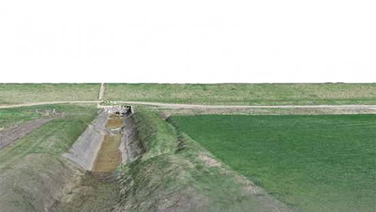
Small unmanned aerial systems (UASs) equipped with an optical camera are a cost-effective strategy for topographic surveys. These low-cost UASs can provide useful information for three-dimensional (3D) reconstruction even if they are equipped with a low-quality navigation system. To ensure the production of high-quality topographic models, careful consideration of the flight mode and proper distribution of ground control points are required. To this end, a commercial UAS was adopted to monitor a small earthen dam using different combinations of flight configurations and by adopting a variable number of ground control points (GCPs). The results highlight that optimization of both the choice and combination of flight plans can reduce the relative error of the 3D model to within two meters without the need to include GCPs. However, the use of GCPs greatly improved the quality of the topographic survey, reducing error to the order of a few centimeters. The combined use of images extracted from two flights, one with a camera mounted at nadir and the second with a 20° angle, was found to be beneficial for increasing the overall accuracy of the 3D model and especially the vertical precision.
How to cite: Manfreda, S., P. Dvorak, J. Mullerova, S. Herban, P. Vuono, J.J. Arranz Justel, M. Perks, Assessing the Accuracy of Digital Surface Models Derived from Optical Imagery Acquired with Unmanned Aerial Systems, Drones, 3(1), 15; (doi: 10.3390/drones3010015), 2019. [pdf]
